By Mike Winn, CEO and co-founder of DroneDeploy
 Solar is the fastest growing form of power generation in the US, surging 41% between 2016 and 2017. While the solar industry is growing fast, it still only makes up 1.9% of the total electricity generated. Solar is projected to comprise 21% of total installed electric capacity in the United States by 2050. To maintain this breakneck growth, and beat the 2050 milestone, the solar industry is now looking to drones for help.
The evolving commercial drone landscape
The solar industry is already adopting drones—with many major solar companies embracing the technology—building on their success in other sectors, where they are prove to deliver 5X+ ROI. For example, construction companies that have implemented in-house drone programs have seen savings ranging from 5-20X, doubled safety rates, and cut project times in half. These savings led to a massive 239% YoY increase in drone use in the construction industry last year.
Solar energy projects are starting to see similar results as solar developers employ drones to decrease costs across every stage of a solar operation from design to construction, and even in ongoing maintenance.
Surveying
Before construction of a solar farm can begin, every solar developer requires up-to-date topographical information about the property. Developers traditionally have two options: rely on publicly available data or conduct a new ground survey. Existing information is typically outdated or lacks the accuracy needed to produce land bids. And conducting new land surveys takes professionals days if, not weeks, often in inhospitable terrain. With a competitive market for bidding and purchasing properties, companies lose potential land opportunities if they don’t move fast.
Drone maps allow surveyors to gather real-time, accurate topographical data 10 times faster, reducing the process down to a few hours in most cases.
Residential solar operations also use drones. These companies face challenges while sending roof surveyors out to a property to take manual tape measurements by clambering across rooftops for 2 to 3 hours. Drone flights—which can be as short as 15 minutes—capture far more accurate measurements without ever having to step foot on the roof. Roof surveyors report they can do twice as many surveys per day, all while achieving higher accuracy and increased safety for their teams.
Design and installation
When it comes to designing the layout for a utility-scale solar farm, the possibilities are almost endless. According to SunPower, a typical site has more than a quadrillion potential plant configurations. Engineers who integrate drone data with thousands of solar farm layouts can compare energy production estimates for each one, reducing the design cycle by up to 70%. The same principles apply to roof designs, giving companies the potential to increase their field productivity by 3X and boost their cost savings by 5X.
Panel maintenance
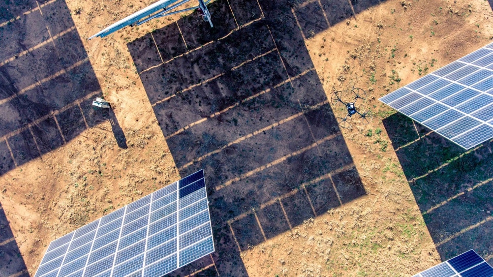
Drones can generate dynamic visuals, including 3D models, elevation data, and high-resolution maps, that aircraft, and satellite imaging cannot deliver. Drones produce maps with half-of-a-centimeter-per-pixel resolution, meaning that surveyors can spot even the most minute details.
But drones go beyond just traditional visuals and can help users see the unseeable.
Thermal imaging has become more accessible on new drones, and are revolutionizing the ability for solar operators to identify panels that are malfunctioning, cracked, or dirty by monitoring large areas in real-time. Instead of manually searching for “a needle in a haystack,” drones provide an instant heat map that helps workers identify problem areas in minutes. These maps eliminate hours from the inspection workflow, transforming a commonly resource-draining process, and making it easier to keep solar panels running at peak efficiency. Some customer estimate an overall 1-2% increase of Megawatts generated, given increased speed to identify and fix problems.
Reducing all-in solar system costs
As sites become more distributed, increasingly remote, and reach a bigger scale, the cost-saving effect of drones will only be amplified. Consider the distributed nature of solar projects. Drones can access difficult to reach places, which increases the efficiency of maintenance crews and eliminates the complexity of inspecting, repairing, and reporting issues.
In 2011, the Department of Energy launched the SunShot Initiative to reduce the total costs of solar energy by 75 percent. They found that from project management to inspections and maintenance, drone applications in solar can lower energy costs from $0.07 to $0.03 per kWh. Specifically, drones drive down design, project development, and construction costs; can improve asset health with better monitoring and therefore extend the lifetime of projects, and lower operation and management labor-related costs.
The impact of drones in the solar industry
As drone use continues to increase in the solar industry, so too does the potential that solar energy will become a primary source of all electricity in the United States and the rest of the world.
The views and opinions expressed in this article are the author’s own, and do not necessarily reflect those held by pv magazine.
This content is protected by copyright and may not be reused. If you want to cooperate with us and would like to reuse some of our content, please contact: editors@pv-magazine.com.

By submitting this form you agree to pv magazine using your data for the purposes of publishing your comment.
Your personal data will only be disclosed or otherwise transmitted to third parties for the purposes of spam filtering or if this is necessary for technical maintenance of the website. Any other transfer to third parties will not take place unless this is justified on the basis of applicable data protection regulations or if pv magazine is legally obliged to do so.
You may revoke this consent at any time with effect for the future, in which case your personal data will be deleted immediately. Otherwise, your data will be deleted if pv magazine has processed your request or the purpose of data storage is fulfilled.
Further information on data privacy can be found in our Data Protection Policy.