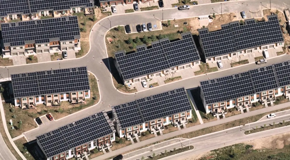
Gone are the days of relying solely on ground-level surveys. Today, high-resolution photographs and 3D models generated from aerial imagery paint a comprehensive picture of any given piece of land.
Location intelligence—the process of deriving meaningful insights from geospatial data—and aerial imagery are becoming more prominent in the solar industry. These tools are reshaping the solar power landscape, enabling developers to identify the best areas and layout for solar farms, as well as the optimal tilt of solar panels for increased sun exposure. These changes are not only bringing efficiency upgrades; they are paving the way for timely and relevant solutions to address ongoing climate issues that promise to propel the U.S. toward a more sustainable future.
Tech-driven solar solutions
In 2023, solar energy represented over half of all new electricity-generating capacity added to the U.S. grid, underscoring a strong societal shift towards renewable energy. The proliferation of solar energy projects benefits from advancements in aerial imagery technology and location intelligence, as aerial imagery offers a clear and comprehensive view from above. From these images, engineers can glean up-to-date information about the landscape and measure key areas remotely, enabling them to minimize costly and time-consuming on-site visits for peak efficiency.
Location intelligence provides detailed insights that reveal everything from subtle shading patterns to potential obstacles, empowering engineers to design solar farms with laser-sharp precision. This meticulous planning ensures optimal panel positioning, maximizing energy capture and ensuring every sunbeam is harnessed effectively.
And beyond efficiency, location intelligence aids in the integration of solar farms into local landscapes and communities, minimizing visual impact and fostering coexistence with residents. Solar farms, supported by local buy-in and the insightful application of technology, are set to become an integral part of the U.S. energy landscape.
Sustainability implications
Greater access to increasingly sophisticated aerial imagery and location intelligence technology can also help U.S. communities produce clean(er) energy and minimize carbon footprints to achieve sustainability goals. These tools are crucial in the solar panel installation process, as they help in identifying the communities and infrastructure that are most suitable for solar panel deployment.
Though solar farms are largely located in rural areas, increasing use and accuracy of location intelligence and aerial imagery technology is also helping cities become more sustainable. Picture this: Sleek, solar-powered facades seamlessly integrated into the design of skyscrapers, transforming them into self-sufficient powerhouses. These very advancements are happening today with the support of location intelligence.
For example, a rapidly evolving technology, building integrated photovoltaics (BIPV) is a material that, as the name implies, is integrated into the building either on new construction or retrofitted after construction is complete. First emerging in the 1970s as aluminum-framed photovoltaic modules, these building-integrated features now take the form of roof tiles, siding or windows that draw in solar rays and convert them directly into energy for the building.
And by analyzing detailed 3D models of buildings generated from aerial data, architects and engineers can then design and install custom-fit BIPV systems to complement the structure’s shape, orientation and energy needs. This ensures optimal energy capture while preserving aesthetics. Moreover, aerial imagery helps map potential shading obstacles like trees or neighboring buildings, allowing for adjustments in the BIPV design to maximize sunlight exposure. The result is stunning buildings that generate their own clean energy, reducing reliance on traditional power sources and contributing to a more eco-conscious society.
Innovative solutions
Location intelligence and aerial imagery technology have set a new standard for a world powered by sunlight, where innovation and environmental responsibility go hand in hand. As insights derived from aerial imagery become more accessible, the deployment of additional solar infrastructure, optimal panel placement, enhanced energy generation and project return on investment become a reality. Government officials and developers that effectively leverage aerial imagery and location intelligence insights are well-prepared to build a brighter future.

Shelly Carroll is vice president and general manager of Nearmap, a location intelligence and aerial imagery solutions provider.
The views and opinions expressed in this article are the author’s own, and do not necessarily reflect those held by pv magazine.
This content is protected by copyright and may not be reused. If you want to cooperate with us and would like to reuse some of our content, please contact: editors@pv-magazine.com.


By submitting this form you agree to pv magazine using your data for the purposes of publishing your comment.
Your personal data will only be disclosed or otherwise transmitted to third parties for the purposes of spam filtering or if this is necessary for technical maintenance of the website. Any other transfer to third parties will not take place unless this is justified on the basis of applicable data protection regulations or if pv magazine is legally obliged to do so.
You may revoke this consent at any time with effect for the future, in which case your personal data will be deleted immediately. Otherwise, your data will be deleted if pv magazine has processed your request or the purpose of data storage is fulfilled.
Further information on data privacy can be found in our Data Protection Policy.