From pv magazine global
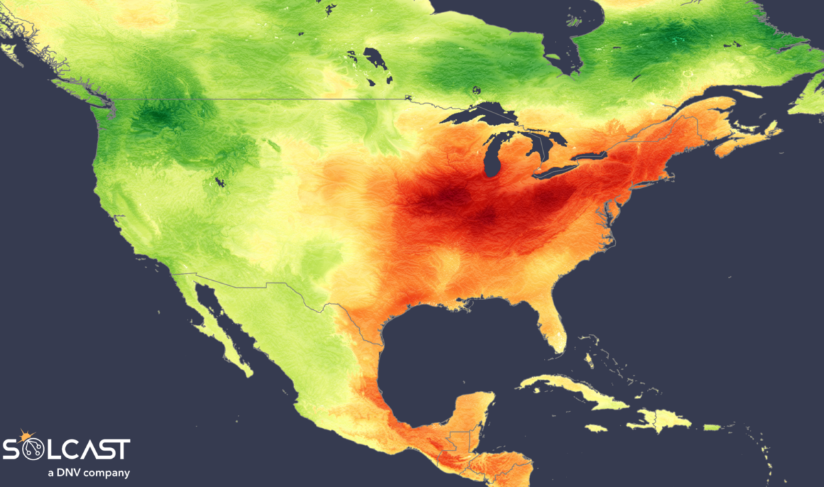
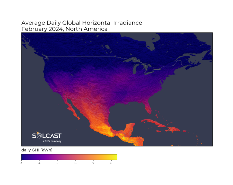
A warm end to winter hit most of North America this February. In the west, during February mild air from the Pacific banked up clouds and depressed irradiance by 10-20%, according to analysis completed using the Solcast API. In the east, persistent high pressure in the upper atmosphere led to irradiance as high as 30% above normal, and new records for solar generation and temperature.
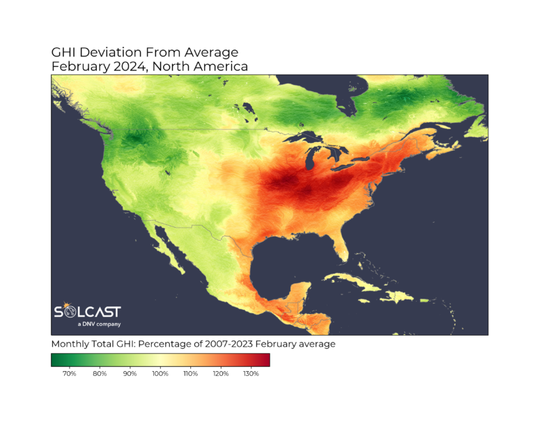
A clear east/west divide is present in the irradiance anomaly this month. A strong low pressure system sat further east than normal over the Atlantic which brought calm, drier and sunny conditions to the Eastern U.S. and Mexico. Sunnier than normal conditions delivered 20-30% more irradiance than normal from Texas to New England. On the west coast however, high pressure was further west over the Pacific, so that coastal low pressure systems pulled moist air from equatorial regions, leading to increased clouds, blocking irradiance.
Clear skies and higher than normal irradiance will have benefited both large and small scale, solar producers. Residential ‘behind the meter’ solar performed strongly this February all over the East Coast. Solcast’s Grid Aggregation model for NYISO shows residential solar peaked at 3.52GW, and saw 23% more solar generation than last year after adjusting for capacity increases. By contrast, CAISO’s residential solar generation was down 12% on the long term capacity-adjusted average.
Utility-scale generation in ERCOT also hit and surpassed their generation peak record, hitting 17.2GW on February 20th. A 50.1% increase in peak generation in February 2023, is mostly a function of capacity increases in the last year.
But it wasn’t just grid performance breaking recent records, temperature records were broken across the country, with the average temperature, more than 4 degrees above normal. Killeen in Texas saw a peak temperature of 38 C (100 F), and Jacaranda trees in Mexico City have been in full bloom all month, 6-8 weeks earlier than normal. Despite the heat further south, areas in Eastern Canada saw significant snowfall caused by a low pressure system stalling over the area, drawing in continuous cold air from the Atlantic. This caused one of the heaviest snowfall events in 20 years, blanketing parts of Nova Scotia with more than a meter of snow.
This extreme weather is reflective of an overall pattern being seen globally, as February 2024 was Earth’s warmest month on record for the 9th consecutive month.
Solcast produces these figures by tracking clouds and aerosols at 1-2km resolution globally, using satellite data and proprietary AI/ML algorithms. This data is used to drive irradiance models, enabling Solcast to calculate irradiance at high resolution, with typical bias of less than 2%, and also cloud-tracking forecasts. This data is used by more than 300 companies managing over 150GW of solar assets globally.
The views and opinions expressed in this article are the author’s own, and do not necessarily reflect those held by pv magazine.
This content is protected by copyright and may not be reused. If you want to cooperate with us and would like to reuse some of our content, please contact: editors@pv-magazine.com.


By submitting this form you agree to pv magazine using your data for the purposes of publishing your comment.
Your personal data will only be disclosed or otherwise transmitted to third parties for the purposes of spam filtering or if this is necessary for technical maintenance of the website. Any other transfer to third parties will not take place unless this is justified on the basis of applicable data protection regulations or if pv magazine is legally obliged to do so.
You may revoke this consent at any time with effect for the future, in which case your personal data will be deleted immediately. Otherwise, your data will be deleted if pv magazine has processed your request or the purpose of data storage is fulfilled.
Further information on data privacy can be found in our Data Protection Policy.