By Yezin Taha, CEO, Nevados Engineering
The decreasing costs of solar power plants has led to unprecedented growth in solar energy generation. However, the availability of flat land is increasingly proving to be a challenge for utilities seeking to meet their solar energy goals. Nowhere is this more prevalent that in areas such as New England, the rolling eastern seaboard states, and mountainous western states, where flat land is at a premium.
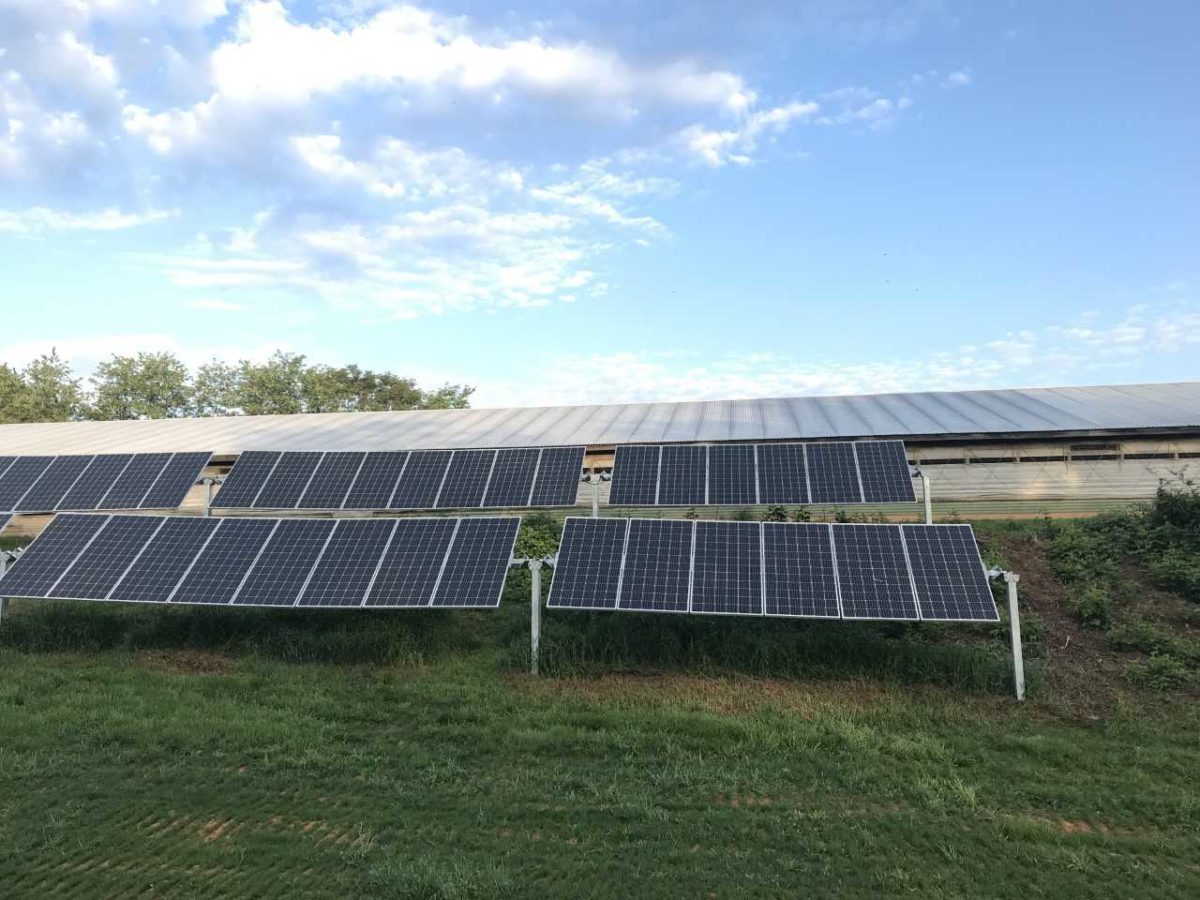
What can a utility do when its territory includes variable terrain? Single axis solar trackers are the most common solution for installing large solar projects, but conventional trackers are limited by the expensive and destructive need to flatten the site prior to installation.
“Land availability near transmission infrastructure and the cost of site prep is a critical issue in delivering competitively priced electricity,” says Evan Riley, vice president of engineering at California-based Brightnight, a solar developer. “To continue to increase the amount of solar on the grid the market must begin to use sites that were previously passed over because they are challenging to develop or build.”
A developer analyzing potential solar project sites can often encounter land grading cost estimates of more than 5% of total project budget. Grading estimates that high often undermine the financial viability of the project. In addition, environmental costs must be factored into these estimates to include mitigating wind-blown dust, rainwater erosion and other environmental factors that result from the grading process. These direct and indirect costs limit the potential locations and investment value of solar power plants.
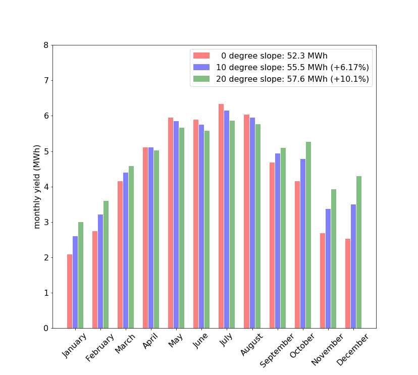
The reason behind this issue is that while standard single-axis solar tracking can increase a solar farm’s annual output by up to 25% versus fixed tilt, conventional tracking systems were designed for flat-terrain install, not sloped or contoured terrain.
Why Move the Mountain? The Value of All-Terrain Trackers
Yet, with today’s technological capabilities installation on sloped and rolling terrain is possible. In fact, sun-facing slopes are desirable since they offer better solar exposure. The result would be highly productive solar installations that decrease installation costs and increase power generation. Based on modeling, trackers on a 17% slope can capture 6% more solar energy than trackers on flat ground, and up to 30% more energy than fixed tilt systems. This qualifies as a financial win for developers and utilities, given that hilly terrain is cheaper to acquire and offers more opportunities for low cost interconnection.
Brightnight’s Riley agrees. “My belief from a development standpoint is that you have to lean into the technology curve. It’s like a shotgun – you have to aim ahead of the clay in order to hit the target.” He should know, he has developed sites that included “severe topographies” and previously oversaw the development and construction of a project on an old coal mining site that generated a healthy financial return.
At the same time, sloped and rolling terrain challenges begin prior to physical construction. Energy generation estimation software such as SAM and PVSyst are not designed to handle variable terrain – they only handle long, straight, parallel rows. Some companies have tried to hack the software, attempting to enable variable terrain modeling, but this is a time-consuming process yielding low accuracy results and poor guidance on how to tilt each row to avoid inter-row shadowing during backtracking on complex terrain. There are also structural loading issues for the foundations – such as the toppling force exerted by the structure being pulled down the hill by gravity.
All-terrain tracker systems (ATTs) are designed to mitigate these challenges by providing flexibility to accommodate rolling terrain. “All-terrain tracking systems have the potential to open up large numbers of sites,” said Riley. “The reason ATTs are inspiring is because they allow projects to be built on sites that would otherwise not be accretive to developers. In this competitive market you won’t be able to create viable projects without the thoughtful project siting and intelligent design that advanced tracking capability supports. In many markets where the best sites are already gone, this is the path to designing power plants with the lowest LCOE.”
What to Look for in All-Terrain Systems
Two methods are currently used to fit trackers to sloped and rolling terrain. Developers can either vary the post heights along the length of a row, keeping the torque tube straight as the ground undulates beneath it, or allow the tracker row to follow the terrain by articulating along its length. Varying the height of the posts to follow natural terrain is limited by how tall the structure can be before construction becomes too challenging and increasing wind loads require too much expensive steel, so this method is limited to flatter land. Articulating along the length of the row allows the structure to mirror the rolling nature of the terrain without causing the construction challenges of an elevated structure. Articulation also allows the same size posts to be used throughout the site, which reduces the total cost of the tracker.
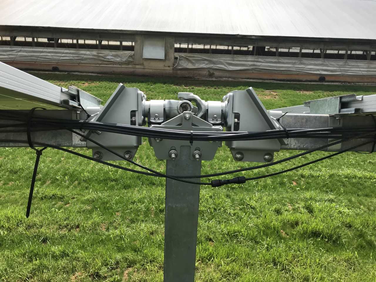
Load distribution along the length of the row is critical on sloped and rolling terrain. On flat land the weight of the structure bears down directly on the posts. However, on sloped terrain, the weight of the structure wants to slide down the hill, which creates an overturning force (“slope load”) on the posts. For conventional flat land trackers there is only one post in the middle that resists this load, so that post must be oversized to manage sloped terrain. Oversizing the central post increases purchase and installation costs, and still limits the total slope the tracker can handle. A better solution is to distribute the slope load across all posts so that no single post must resist the slope load. This allows the same size posts to be used throughout the tracker field, thus reducing purchase and construction costs.
Installation on sloped terrain makes correct placement of posts challenging, which often requires the posts to be removed and reinstalled. This is referred to as “post rejection”, and can dramatically increase project costs. Conventional trackers can manage only a few inches of tolerance for the top of the posts, which results in high post rejection rates. An ATT should have increased post top tolerances to reduce post rejection and aid in construction.
Wind loads on rolling terrain are not the same as on flat terrain. Making sure that your all-terrain tracking system has been well tested is paramount to long-term, repair-free use. An ATT manufacturer should perform accelerated lifetime tests including wind tunnels, fatigue testing, ultimate strength testing, and dynamics and corrosion tests. Obtaining a third-party bankability report that reviews these tests is a must. For instance, at San Francisco-based Nevados Engineering, its ATT has been thoroughly tested and reviewed by a third-party engineer to validate the ability of the tracking system to follow natural terrain and slopes of up to 37%, while also assessing wind tunnel studies modeling the varying wind loads created by variable terrain.
Intelligent Control
While terrain conformant hardware is a baseline, intelligent control systems are the key to effective power generation using ATTs. Unlike flat-land systems, ATT systems require individual row tilt control to avoid inter-row shadows in the morning and evening when the sun is low in the sky. To address this, an ATT requires individual row control versus all rows moving at once.
A shadow of a mere inch across a panel can reduce power generation by 10% or more, so specialized software must be used to analyze shadow fall throughout the site, taking into account the variable post heights along the lengths of each row. The software must then create row-by-row tilt schedules that eliminate inter-row shadowing when the sun is low in the sky. Once the tilt schedules are calculated, an accurate analysis of the energy generation can be completed by specialized production estimate software that accurately analyzes the variable plane of array.
Additionally, automated and responsive controls can help to minimize human intervention and decision making. A good control system should automatically identify inter-row shading events and adjust the tilts of the involved rows, or at least provide the operator with a choice of next steps for optimizing solar power production.
Nevados, for example, offers vision software that analyzes 3D terrain to generate row-by-row tilt schedules and production estimates. The row-by-row tilt schedules are then supplied to the individual row controllers to operate the tracker field without inter-row shading. In the event that shading occurs, or production issues arise with the modules or wiring, a power sensor will detect the power dip and alert the O&M staff to take corrective action if necessary.
Conclusion
Harnessing the solar potential of less expensive variable terrain through all terrain tracking systems can enable utilities, developers, and landowners to produce more energy than from flat land, while increasing ROI. Operators stand to gain from the delta between energy revenue and lower cost land, reduced land development costs, fewer environmental mitigation expenses, and highly terrain-tolerant ATT systems coupled with optimized survey, control, and communications software.
The views and opinions expressed in this article are the author’s own, and do not necessarily reflect those held by pv magazine.
This content is protected by copyright and may not be reused. If you want to cooperate with us and would like to reuse some of our content, please contact: editors@pv-magazine.com.


By submitting this form you agree to pv magazine using your data for the purposes of publishing your comment.
Your personal data will only be disclosed or otherwise transmitted to third parties for the purposes of spam filtering or if this is necessary for technical maintenance of the website. Any other transfer to third parties will not take place unless this is justified on the basis of applicable data protection regulations or if pv magazine is legally obliged to do so.
You may revoke this consent at any time with effect for the future, in which case your personal data will be deleted immediately. Otherwise, your data will be deleted if pv magazine has processed your request or the purpose of data storage is fulfilled.
Further information on data privacy can be found in our Data Protection Policy.