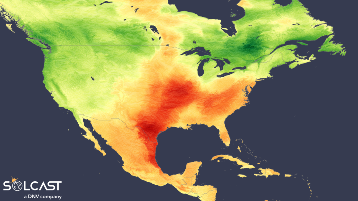
March brought above-average irradiance to much of North America, with the U.S. South, Central America and parts of the Midwest seeing significant gains. However, this sunny condition was not seen everywhere. Solar producers in Canada and across the western U.S., including the large solar installations in California, Arizona and Nevada, experienced diminished irradiance with some cases substantially below normal. According to analysis using the Solcast API, this month’s pattern reflects a split across the continent, with storm activity dropping irradiance on the West coast and high pressure systems keeping the East clear and dry.
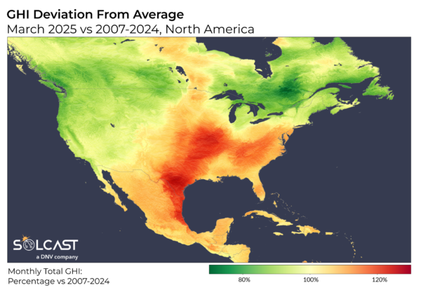
In the U.S. South and Midwest, irradiance surged far above the March norm. Southern Texas stood out with irradiance reaching 30% above average, while broader swathes of the Southern states have seen increases of 20% or more. Even those regions that ‘missed out’ recorded irradiance anomalies between 10% and 20% above climatology. These clear sky conditions coincided with significantly lower precipitation, intensifying existing drought concerns in the Great Plains. Though March is typically a transitional month prone to volatility, this year was particularly active. High temperatures and frequent storm development contributed to an environment that favored persistent sunshine over cloud-forming moisture in these regions.
In contrast, much of the U.S. West and Canada were marked by lower-than-average solar irradiance. Most of this region saw irradiance 10% below average in southern areas, with some northern areas dipping by as much as 20%. Canada was particularly affected, with Quebec seeing anomalies approaching 30% below average. Pressure patterns high in the atmosphere showed signs of a colder, stormier air mass over the Northern U.S. and Canada due to a jet stream dip. This configuration allowed Pacific moisture to push deep inland, resulting in widespread cloud cover. In the Atlantic, a strong Azores high and a potentially positive phase of the North Atlantic Oscillation (NAO) may have played a role by redirecting storm tracks and reinforcing persistent cloud cover over the northeast.
Meanwhile, Central America benefitted from generally clear skies. Irradiance was slightly above average across the entire region, with northeastern Mexico experiencing a notable spike of 30% above the March norm. This increase appears linked to high pressure over the Pacific, which brought northerly winds funneling dry air from the Chihuahuan Desert southward.
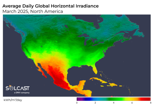
Solcast produces these figures by tracking clouds and aerosols at 1-2km resolution globally, using satellite data and proprietary AI/ML algorithms. This data is used to drive irradiance models, enabling Solcast to calculate irradiance at high resolution, with typical bias of less than 2%, and also cloud-tracking forecasts. This data is used by more than 350 companies managing over 300 GW of solar assets globally.
The views and opinions expressed in this article are the author’s own, and do not necessarily reflect those held by pv magazine.
This content is protected by copyright and may not be reused. If you want to cooperate with us and would like to reuse some of our content, please contact: editors@pv-magazine.com.


By submitting this form you agree to pv magazine using your data for the purposes of publishing your comment.
Your personal data will only be disclosed or otherwise transmitted to third parties for the purposes of spam filtering or if this is necessary for technical maintenance of the website. Any other transfer to third parties will not take place unless this is justified on the basis of applicable data protection regulations or if pv magazine is legally obliged to do so.
You may revoke this consent at any time with effect for the future, in which case your personal data will be deleted immediately. Otherwise, your data will be deleted if pv magazine has processed your request or the purpose of data storage is fulfilled.
Further information on data privacy can be found in our Data Protection Policy.