October delivered record-high irradiance across much of the United States, with a high-pressure system over the Eastern and Central regions driving a sustained period of warm, dry, and clear weather. Meanwhile, contrasting conditions in Canada’s coastal provinces and extreme weather in Florida underscored this month’s diverse impacts on North American solar generation, according to analysis using the Solcast API.
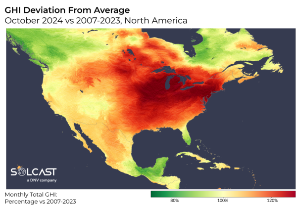
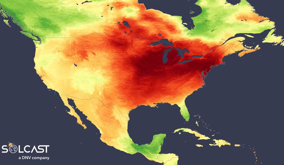
An unusually stable high-pressure zone dominated skies over the Central and Eastern U.S., suppressing cloud formation across much of the country. Clear skies, coupled with minimal rainfall, drove irradiance levels far above seasonal norms, especially in parts of the Midwest
and Great Lakes regions.
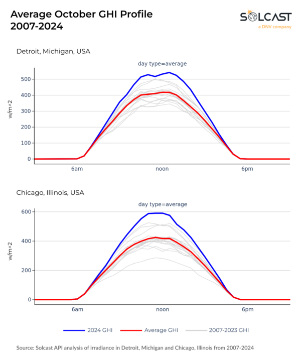
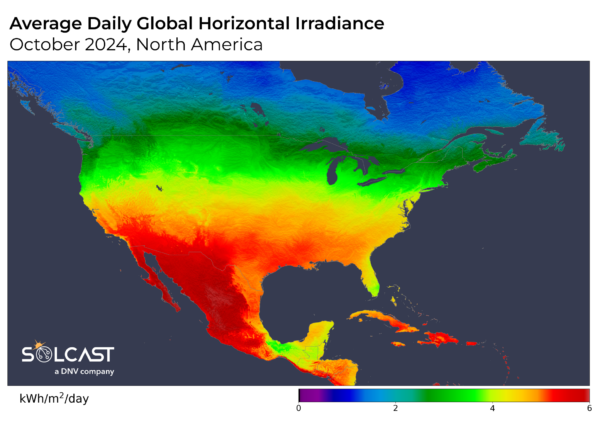
Chicago and Detroit, in particular, saw their highest average monthly irradiance in at least 18 years, with levels up by 40% and 30% respectively compared to a typical October. These metrics also exceeded the second-highest irradiance records by 13% and 8%, respectively. For context, Northern US states saw the same or more irradiance in October than Portugal and Spain. As seen in the data below, solar installations across these areas experienced optimal generating conditions rarely seen in October.
The extreme jet stream position also created a distinct East-West divide in solar irradiance across the U.S. With high pressure more concentrated over the east, irradiance anomalies tapered off further west. The Upper Midwest—covering states like Wisconsin, Michigan, and Illinois—stood out for its high irradiance records. This area benefited from persistently clear weather, experiencing warmer-than-average temperatures that would be more typical of early autumn than mid-October.
While much of the U.S. experienced clear skies, Canada’s British Columbia and Quebec were impacted by lower pressure systems, which brought overcast conditions, frequent rainfall, and strong offshore winds. Irradiance in these coastal provinces dropped to 80% of
typical October levels, and mean temperatures were up to 4 C cooler than average. Vancouver, in particular, saw stronger offshore winds and increased rainfall, significantly reducing available sunshine for solar production throughout much of the month.
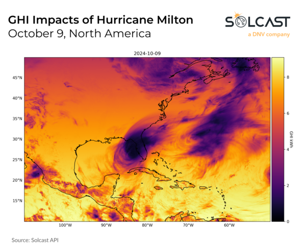
October’s record irradiance highs also contrasted sharply with conditions in Florida, where Hurricane Milton made landfall on October 9, disrupting irradiance across the southeastern U.S.. Milton delivered extreme rainfall and brought severe flash flooding across the state.
The impact of the Category 4 hurricane on irradiance is visible in the image above, driving significant irradiance impacts on the day of its landfall, with the associated cloud depressing October irradiance for all of Florida.
Solcast produces these figures by tracking clouds and aerosols at 1-2km resolution globally, using satellite data and proprietary AI/ML algorithms. This data is used to drive irradiance models, enabling Solcast to calculate irradiance at high resolution, with typical bias of less than 2%, and also cloud-tracking forecasts. This data is used by more than 300 companies managing over 150GW of solar assets globally.
The views and opinions expressed in this article are the author’s own, and do not necessarily reflect those held by pv magazine.
This content is protected by copyright and may not be reused. If you want to cooperate with us and would like to reuse some of our content, please contact: editors@pv-magazine.com.


By submitting this form you agree to pv magazine using your data for the purposes of publishing your comment.
Your personal data will only be disclosed or otherwise transmitted to third parties for the purposes of spam filtering or if this is necessary for technical maintenance of the website. Any other transfer to third parties will not take place unless this is justified on the basis of applicable data protection regulations or if pv magazine is legally obliged to do so.
You may revoke this consent at any time with effect for the future, in which case your personal data will be deleted immediately. Otherwise, your data will be deleted if pv magazine has processed your request or the purpose of data storage is fulfilled.
Further information on data privacy can be found in our Data Protection Policy.